|
|
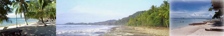
About Cataingan |
|
|
|
||
|
|
||
|
|
ABOUT CATAINGAN Source: File - Cataingan Municipal Office Prepared by: Mr. Alberto Borrel, Jr. (+) Contributed by: Mrs. Maribeth Marabe Alvarez
I – INTRODUCTION / GENERAL FEATURE:
BRIEF HISTORY OF THE MUNICIPALITY
In 1885 when Damaso Tamayo was the Governadorcillo (later on called Capitan Municipal) of Palanas, Cataingan was just a barrio which owed its allegiance to the mother town of Palanas.
The site on which the present town is located had been a part of the pasture land of Don Jose Muños, a Spaniard who was then resident of Manila. His administrator, Don Fernando Orizando built several corrals in the interior part where cattle were kept at night. Those corrals to graze in the meadows, the animals strolled to all parts of the pasture, so that every place was practically covered with manure. Because of this manure which covered daily the present site of the town, the people always referred to it as “Kataijan” meaning the place of manure. People from the different place who visited this place used to call it “Kataijan”. In the course of time between 1881 and 1882, and because of its derogatory connotation, the inhabitants through the advice of Alejandro Yanson changed it to “Cataingan” which has close derivation from its original name.
Along the shore of the bay Alejandro Yanson, Anastacio Deogrades and several others built their houses which later on formed into barrio, under the strong leadership of Alejandro Yanson, the inhabitants sought the help of Don Jose Cabañas, governor of Palanog (now Masbate) for the separation of Cataingan as an independence municipality.
Accordingly in 1884, the petition was sent to the governor thru Damaso Tamayo, the Governadorcillo of Palanas. This petition was later on submitted to Manila for approval. On July 7, 1885, the separation of Cataingan as an independent municipality was approved by Governor Terrero. Immediately after the separation of Cataingan, Alejandro Yanson was appointed Capitan Municipal, and Anastacio Deogrades as Teniente Absolute.
II – DEVELOPMENT OVERVIEW
The land area of Cataingan has rugged and broad territory of 19,177.9173 hectares with rolling terrains and wide plains suited for agriculture, ideal for cattle-raising and other agricultural products. If properly harnessed and scientifically developed, can feed the teaming population of Masbate province. It has vast area rich in mineral resources hidden deep in her bosom untapped. It has vast deposits of guano of commercial quantity. Likewise, there are deposits of copper, coal and phosphate rocks believe also to be in commercial quantities. Its long coastline is rich in marine resources. It has a new port and sea wall, protected by the scenic beauty of Matayum and Mintac peninsula. All those potentials of Cataingan are waiting for cunning hands of ingenious man to be harnessed and developed. Other assets of Cataingan are her developed elementary and high schools, several public and private schools which serve as feeders for establishments of a university worthy to be the vertex of an advanced future civilization.
III – PHYSICAL PROFILE
At the southern tip of the island of Masbate, and situated at the foot of the narrow peninsula, which serves as wind break, nestles the peaceful and lovely town of Cataingan, the famous rice and corn granary of the Province of Masbate.
LOCATION
The Municipality of Cataingan is located at the southeastern part of the Province of Masbate. The Poblacion itself is situated in a coastal bay, usually referred as Cataingan Bay, which is around sixteen (16) square kilometers. In the entire province it ranks 3rd to the Municipality of Masbate in terms of income and 4th in terms of population.
It consists of thirty six (36) barangays and has a total population of 46,593 as per census of 2000. It has a total land area of 19,177.9173 hectares.
Its location is strategically superior in terms of commercial and agricultural expansion. Being situated at a harbor, it is a safe refuge for steamers, vessels, motorboats and sailboats during inclement weather. It has a port itself and sea wall which serves as protection from heavy waves. Thus, making it a center of trade in the various municipalities of the Province of Masbate and of the Province of Samar, Leyte, Cebu, Iloilo, Bohol, Negros and the island of Panay.
TOPOGRAPHY
The physical feature of Cataingan is generally rugged with several fertile plains between the elevations. Although the central part is hilly, it is traversed by several rivers which provide fresh water to the thousands of cattle, carabaos, and other livestock which eventually made this town once famous for cattle-raising. Yearly it exported to Manila and Cebu and the neighboring provinces no less than a thousand heads of cattle, carabaos and horses.
The northern part of Cataingan is mountainous and it is here where the highest peak is located, towering at a height of 300 feet. The lowest elevation is to be found at the coastal part of the Poblacion which has an elevation of 10 feet. From the highest peak going southward to Cataingan Bay are found rolling hills of grassland, coconuts and corn land with an average of 50-60 feet elevation.
There are also main rivers among which are the Gahit River, San Pedro and Concepcion. This is the river where NIA has constructed the finished Irrigation Dam. And it is expected to irrigate 80 hectares of Riceland. The next is the Bagacay River originating from Mount Bagacay of Barangay Tuybo, going down to Domorog River and extending to Hampangan, Tagboan. Like the Gahit River, a dam is constructed on this river. This structure is also expected to irrigate 130 hectares of Riceland.
Another river is found at Barangay Nadawisan extending towards Barangay Osmeña meeting the Bagacay River and the Cagbatang River which also originate from Tuybo and extending between the barangays boundaries of Estampar and Cadulawan.
CLIMATE
The climate of this municipality is considered “Type 3”, which is characterized by wet and dry seasons. The months from May to October are relatively rainy, but maximum rain periods are not pronounced. Cropping is usually from April to November.
Typhoon is prevalent during the month of June. The normal track of wind usually originated from the eastern part of the municipality with a velocity of 10 knots (Typhoon Map).
SOIL CLASSIFICATION
By actual observation of some agriculturist assigned in this municipality, so many years had passed, in the formulation of agricultural production, it was classified as follows, the soil on the municipality of Cataingan:
These different kind of soil were declared capable to major agricultural crops depending on scientific methods applied to each classification. Capabilities to each soil classification were unexplained derivatively, due to concentration on the promotion of soil analysis using the right kind of soil to farmer cooperator suited for farming.
WATER RESOURCES
Municipality of Cataingan is composed of 36 barangays and every barangay has its own source of potable water, it only needs proper development to make it easier to convey, and with the help of the Rural Health Unit personnel and other agencies, this municipality maintains safe potable water.
MINERAL DEPOSITS
In this municipality, mineral source could be tapped to provide raw materials in the production of organic fertilizers, is a sufficient amount of guano deposits which are located in the barangays of San Rafael, Libtong, Pawican and San Pedro.
THE FACILITIES
Transportation: 1. By air - Asian Spirit Airlines (Manila-Masbate-Manila) - Daily
2. By sea - M/V Cebu Princess (Masbate-Cebu-Masbate) - MWFSun - M/V Rosalia-I (Cataingan-Cebu-Cataingan) - TTHSat - M/V Cathlyn (Dimasalang-Bulan-Dimasalang) - Daily - Montenegro Shipping Lines (Masbate-Pilar, Sorsogon-Masbate) - Daily - Motor vessels on daily trips (Samar-Cataingan-Samar)
3. By land - L300 vans, Passenger Jeepney's, & the likes are on daily trips to Masbate City.
Entertainment: 1. Charles Cable Television 2. Direct-To-Home Television (via Philippines owned Satellite - Agila 2) 3. Bars & Restaurants are available around the town
Communication: 1. Smart Philippines 2. Globe Telecommunications 3. PilTel 4. PT&T 5. Cataingan Post Office
Computers & Internet: 1. Lee Internet Cafe 2. Smart Wi-Fi
|
|
|
|
||